|


|
|
|
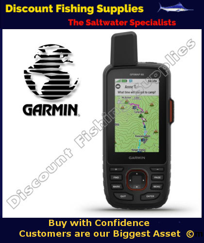
Garmin Handheld GPS 66i
OB-010-02088-03
|


You might also be interested in ...
Special Offer

$325.00 $295.00
Save $30.00
GST Incl - NZ purchases only
Special Offer

Special Offer

Special Offer

CONTACT US
|

Where navigation meets global communication. The GPSMAP 66i premium handheld has built in topographic charting to map your journeys, but also has the breakthrough ability of two way texting to any mobile device and triggering an SOS to rescue monitoring centre via global Iridium satellite network (inReach subscription required).
Precise Garmin navigation meets global communication in the GPSMAP 66i premium GPS handheld with inReach® satellite technology.
Built for Tough Treks
The sturdy, button-operated GPSMAP 66i features a large 3” color display you can see even in bright sunlight. If you’re out in the field for long stretches of time, you can turn on Expedition mode and get up to 200 hours of battery life while using inReach technology. In the default tracking mode, you get up to 35 hours of battery life, and your device will save your location every 10 minutes.
Satellite Communication
Staying in touch is vital, even on less challenging trips. Using inReach technology (subscription required), this handheld lets you trigger an SOS to the GEOS 24/7 emergency response team for interactive support in an emergency. It also enables two-way messaging and LiveTrack location sharing via the 100% global Iridium satellite network, so you can stay in contact with loved ones, teammates, headquarters and more.
Navigate with Confidence
GPSMAP 66i is fitted with the best in Garmin navigation. Preloaded Garmin TOPO mapping provides detailed views of terrain contours, topographic elevations, summits, parks, coastlines, rivers, lakes, and geographical points. Direct-to-device downloads of BirdsEye Satellite Imagery provide high-resolution photo-realistic views of your route, trailheads, clearings and more — without an annual subscription. Support for multi-GNSS combined with altimeter, barometer, and compass navigation sensors lets you track and navigate in challenging environments.
Weather Anywhere
Wireless Cellular connectivity lets you access Active Weather for up-to-date forecasts, including predictive maps for temperature, wind, precipitation, and clouds — right on the handheld when connected to Garmin Connect Mobile.
Pair with Your Mobile Device
The free Garmin Explore mobile app lets you plan, review and sync data, including waypoints, routes, activities, and collections. Review completed activities while still in the field, even when you’re off the grid. The app also lets you sync your GPSMAP 66i with your compatible mobile device so you can access unlimited maps, aerial imagery, and U.S. NOAA charts. You can even use all of the inReach features on your paired mobile device. For easier messaging, you can access your phone’s contact list from the Garmin Explore app to connect with fewer keystrokes. Plan for future trips and review previous activities from the Garmin Explore website.
Garmin Handheld GPS 66i Features:
Display: 3" colour screen 240 x 400 pixels
Trigger an interactive SOS to the 24/7 search and rescue monitoring centre. Send and receive text messages to SMS and email or message with other inReach® users and exchange locations via satellite inReach technology (Subscription required)
Preloaded Garmin TOPO mapping with direct-to-device BirdsEye Satellite Imagery downloads
Track and share location with friends and family on web-based MapShare® portal
Virtual keyboard for custom text messaging
Garmin Explore™ and Garmin Connect™ IQ compatible
Access to weather forecasts for current location and planned destination when connected to Garmin Connect Mobile when you have cellular coverage
Battery: lithium ion rechargeable battery. Battery life up to 35 hours at 10-minute tracking; up to 200 hours at 30-minute tracking (power save mode)
16 GB internal memory
Micro SD card slot for extra charting
High speed USB and NMEA 0183 compatible
10,000 Waypoints and 250 routes
3-axis compass with barometric altimeter
IPX7 Waterproof
Physical & Performance:
Physical Dimensions: 2.6” x 6.4” x 1.4” (6.6 x 16.3 x 3.5 cm)
High-Sensitivity Receiver: Yes
Interface: High-speed USB and NMEA 0183 compatible
Display Size: 1.5"W x 2.5"H (3.8 x 6.3 cm); 3" diag (7.6 cm)
Water Rating: IPX7
Display Resolution: 240 x 400 pixels
Weight: 8.5 oz (241 g)
Display Type: Transflective colour TFT
Battery: Rechargeable, internal lithium-ion
Battery Life: Up to 35 hours at 10-minute tracking; up to 200 hours at 30-minute tracking (power save mode).
Maps & Navigation:
• Waypoints/Favorites/Locations: 10000
• Track Log: 20,000 points, 250 saved gpx tracks, 300 saved fit activities
• Preloaded Maps: Yes (topographic)
• Routes: 250
• Storage and Power Capacity: microSD™ card (not included)
• Basemap: Yes
• Memory/History: 16 GB
• Ability To Add Maps: Yes.
What's in the Box:
• GPSMAP 66i
• Access to Birdseye Satellite Imagery
• USB cable
• Carabiner clip
• Documentation.
KEYWORDS:
Garmin Handheld GPS 66i, garmin, GPSMAP66i, marine gps, waterproof gps, marine gps, handheld gps, 66i, OB-010-02088-03,